A tube line that never was

From the ianVisits Unbuilt London category, this never built figure of eight tube line:

Eight? More like the Infinity Line.

And actually not a bad idea. It would have connected all the big London mainline stations.

I remember a time when I was constantly trying to get from Victoria to Waterloo. Can’t recall why, but I was. Very annoying, for such a short distance. This says 6 minutes, if you change at Westminster Tube. Fantasy. Often I just walked.

But guess what. Victoria-Waterloo would have remained a nightmare on the Infinity Line, taking you either via Kensington and Paddington or via Kings Cross and Liverpool Street. Which is why the name would have stuck.

New River walk with GodDaughter1 from Bounds Green to Enfield

On April 2nd 2016, GodDaughter1 and I went on a photo-expedition along the New River. It was most enjoyable, and I prepared another of those big photo-clutches that I could seldom bother to do on the Old Blog, so that you can now, if you feel like it, click-click-click through them on this New Blog. But I also wanted to link back to an earlier posting I did about a rather exotic looking duck that we had encountered that same day.

For reasons explained in this posting, all postings on the Old Blog linked back to from this blog have to have been transferred to the New Blog. So, here I am linking back to What sort of duck is this?

But, problem. That posting itself linked back to a posting about Trees pruned into strange sculptures, because GD1 and I encountered a really strange piece of tree surgery (photo (6.2), on that same expedition.

Which, in its turn linked back to Losing the leaves in Victoria Park, because, well, because it did. So that had to be transferred across too.

When I put it like that, it all seems pretty simple. But following the link chain backwards and then forwards again, opening up each posting about four times over, was the Grandma of all muddles that I had not seen coming, and muddles you do not see coming can get really muddled.

Anyway, it’s all sorted now, and here are all those photos I mentioned, at the top of this:

My favourite is the plate-shaped foliage that has been emptied upside down into the water (photo 28 (4.4)).

There’s lots more I could say about all these photos, but this posting has already gone on far too long, and I confine myself now to saying: See also the plaque about Sir Hugh Myddelton (photo 37 (5.5)), who designed the New River. Designed? You don’t design rivers. They’re just there. But yes, he designed it. The point being it was designed and built, to supply London with fresh water, right at the beginning of the seventeenth century. So, at a time when so many stupid things were in the process of happening, something truly creative also happened.

Well, one other thing: the occasional interpolation of extreme urbanness (e.g. a newspaper headline about Ronnie Corbett (photo 27 (4.3)) and the van covered in stickers (photo 21 (3.5)) is because when you walk along beside the New River, it sometimes dives underground and you have to go up to regular London, until you get to the next bit.

June 6th etc. in ten seconds

I like this:

But I’d like it a lot more if it was slowed down. Or at least slowable down. The early stages when it was fairly static work well. The later bits, when the Americans raced around the south, creating the Falaise Pocket, and then how that Pocket emptied, are too quick to tell the story. You have to know it already.

Even so, what a story.

The first two photos on the old blog

I have resumed copying old postings over from the old blog to the New Blog. The situation with linking to the old blog has got worse. It used to be that it merely said “Dangerous” in scary red lettering, at the beginning of the link. Now the entire destination is turning bright red. You can still find your way to the old blog if you really want to, but the red screen is decidedly offputting. All the more reason for me to shovel stuff over to here.

This time around, instead of just picking postings at random, or because I wanted to link back to them, I simply started at the beginning. Mostly it is highly unrecommendable housekeeping babble, although don’t let me stop you looking at it if you really want to. But, the first two photos on the old blog struck me as really good and worth another look.

First, this photo, of a photoer, photoing away in Parliament Square, featured in this posting:

What’s so good about this is that (a) the camera is now so antiquated, but that also (b) we can observe a now obsolete tourist habit, that of staggering around London with a camera in one hand and a big old map in the other. Now, all of the above is done, and done much better, with a tiny little thing smaller than the camera she’s using.

There’s even a Parliament Square statue in the background.

I’m pretty sure I chose this photo quite carefully, for the honour of being the first photo on the new blog, as it then was. But even if your opinion of this photo differs from mine, then and now, you’ve got to agree that this second one is pretty cool:

The bridge of the century so far, and no sign of anything better coming any time soon.

Sadly, the third photo is pretty crap.

Out east – one year ago today

I looked at what I was doing a year ago today, and came across these photos, of a great little expedition I had out east:

My wanderings began at West Silvertown DLR, from which there is a great view of the Tate & Lyle factory or refinery or whatever it is, the one with the giant can of Golden Syrup attached to it. Other local landmarks included: that cruise ship next to the footbridge, which is actually a hotel; a superb crane cluster off to the north; the Dome; that skilift Thing that goes across the River; and the Optic Cloak. (Where the Eastern God (Buddha?) was, I don’t recall, but I like him a lot.)

This is the area I was exploring:

It’s a place that is palpably in transition. Go back today, and it’ll be different. A year from now, it’ll be different again. In ten years, unrecognisably different. The landmarks in the distance will still be there, but the foreground will be transformed.

The weather that day (unlike the weather today) was a bit grim and grey, but I remember really enjoying this expedition.

I also, that day, photoed nesting birds, cranes, and a book of the week. That last posting having been done as soon as I got home.

By the way, behind the cruise ship is the ExCel Centre, now in the news because it was turned into a hospital. A hospital which had remained mostly empty, and now seems like it will soon shut. Which is good.

Photo-question answered

There I was, sitting in a window seat of a Ryanair 737-800, trying and pretty much failing to photo photos out of the window. But I did succeed in photoing this photo:

When I looked at this photo again, I wondered just exactly what that elongated rectangular bit in the middle was, surrounded by darkness, that looks like a word spelt out in an unfamiliar alphabet? I cranked up Google Maps, and searched, all around Stansted. Nothing. The key to it was that highly idiosyncratic motorway intersection at the top. Couldn’t find it anywhere, until I started casting the net wider, and I found it, way out west of London, where the M4 and the M25 cross.

It was here:

There really is no doubt about it. All the details fit. The rectangle of weird lettering is Heathrow Airport. At first I thought this was going to be another mystery posting, for Commenter Chuck or Commenter Alastair to solve. But, no need. Already solved.

So, Ryanair planes fly from France to Stansted, right over Heathrow. I guess the airplanes landing at and taking off at Heathrow are way too low to be bothered about airplanes like the one I was in.

Churchill War Rooms gallery

One of the nice things about people coming to stay is that you often find yourself visiting touristy but interesting things that you’d never quite get around to seeing on your own. Later, maybe, but not today. It’ll always be there won’t it?

Touristy things like: the Churchill War Rooms. In February of last year, nearly two years ago now, GodDaughter2’s Dad was in town, and that’s one of the places we went.

And I took the odd photo or two. Well, more like 350, of which here are 84:

A big spread of photos like that would have been an impossibly tedious operation to stick up at Brian Micklethwait’s Previous Blog, and an equally tedious business for you to be scrutinising. But now, here they all are, and you can do the usual, clicking through as quickly or as slowly as you like. Enjoy. Especially if you rarely or never visit London, and have no plans to see this place for real.

There’s a million things I could say about it. One of the more striking of the photos above is photo 33, which shows how thick the concrete was protecting everything, from all but the most direct of direct hits, that passage that you see having been drilled through afterwards, when they were turning these working spaces into a place people could visit and circulate around.

Other talking points? Well, lots of signs and souvenirs, often signs made into souvenirs, for sale in the inevitable gift shop. And also: signs that are not Original but Modern. Signs with lots of words. Which is appropriate, given how important Churchill knew words (see photo 80) to be.

Most of the human figures that you see are not real; they’re sculpted. And “Other creatures” is in the category list because, inevitably, there are bulldogs.

I did all the hard work for this posting before I got ill, and I’m still not fully recovered. So, please continue to wish me well.

A sixteenth century map of the world

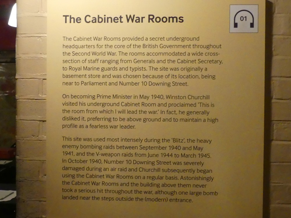
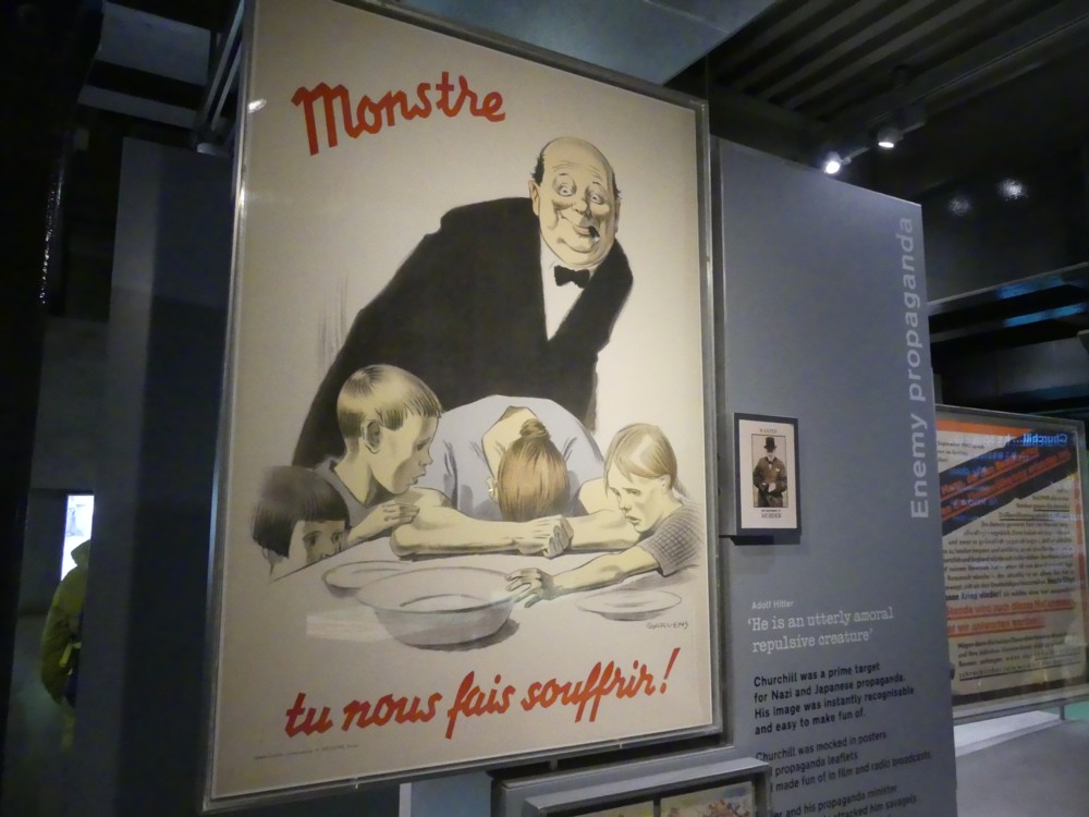
Via Twitter, and something called Map Porn, I found my way to this world map drawn by Ahmed Muhiddin Piri in the 16th century:

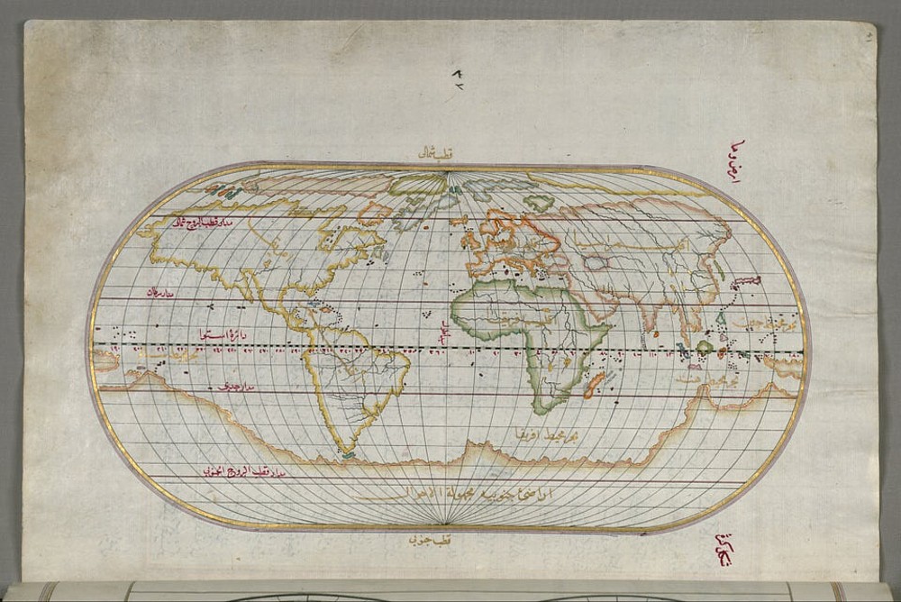
Yet I can only find one other reference to it on the www, in the form of a print of the above which is for sale, here, where it’s described as a “Fine Archival Reproduction”. So far as I can work it out, this is a bodged together guess about a map that “Ahmed Muhiddin Piri” (aka “Piri Reis”) did create, but which only survives in the form of a small fragment. We know he knew enough to have created such a map. So, hey, we did create it. But I could be completely wrong about this, because I’m still trying to get my head around it all. Perhaps this is a copy of a real map. Maybe the internet is full of descriptions of it, which I merely failed to find.

The reason I’m interested in this map, or the maps that enabled this map to be made, is that it illustrates how much more they knew about the geography of the world in other parts of the world than Europe. When Europe “discovered” the rest of the world, this wasn’t Europeans discovering a primitive and poverty-stricken place, which only started getting rich after they’d discovered it. What the Europeans discovered was lots of places far richer than Europe, like India and China. And that’s just what the Europeans were trying to do. Just because they also “discovered” such places as Australia and North America, which were poorer, doesn’t mean that their basic motive was to conquer the world. No, what the Europeans were trying to do was get connected with an already thriving world, from which they could import mystical luxuries like spice, and from which they could learn, but which they were stopped from doing, by the conquest of the Middle East by Islam. So, the Europeans decided to go round. Round Africa. Round the world, by going west. (That being why the West “Indies” got called “Indies”. And why the people we now call Native Americans were know for many decades as “Red Indians”. Still were, when I was a kid. And still are, by some.)

The European economic breakthrough that made its presence felt in the late 18th century was, globally speaking, something of an end run, as Americans would say. As I learned from that book I’ve been enthusing about by Steve Davies, Europe remained disunited, developed modern guns and never stopped developing them, starting winning wars against the likes of Indians (real ones, in India), then went from inventing and improving guns to inventing and improving everything else and thus unleashed the Industrial Revolution. Europe only got out in front rather late in the story. Oh, it was special. But so were lots of other places.

As the above map illustrates. Or, I think it does.

And maybe it also illustrates something else. Interestingly, the one big thing it gets wrong, the thing only people nearby then knew about properly, was Australasia. Rumours about northern Australia made people think that Australia was part of what we call Antarctica. New Zealand? Again, locals on boats in islands to the north presumably knew about it. But people like Ahmed Muhiddin/Piri Reis, and his various informants? They had no idea.

Christmas is coming – the goose is getting illuminated (and pursued by Sherlock Holmes)

Indeed, in Marylebone Road:

The same night I photoed the car and the leaves and Sherlock Holmes smoking.

I photoed many photos of these geese, in their clutches of four on each street lamp, while waiting for the Curry Night Boys to assemble, my favourite photo being this one …:

… because it turns the four geese into something that looks more like one giant insect. If I had showed only that one, it might have taken you a few moments to work out what was going on.

Okay, so, apart from four geese on each street light, what is going on? Why these geese? And why those strange blue smudges?

It took me a while, but eventually I came across this guide to Christmas street lights, which comes complete with a street map of the Baker Street “quarter”. These Marylebone Road geese are lights clutch number one:

Inspired by the Sherlock Holmes story, The Adventure of the Blue Carbuncle, the ornate lamppost columns marking the gateway to the Quarter feature illuminated geese sporting blue jewels (carbuncles).

So, Sherlock Holmes again. If you are in that particular bit of London, you can’t escape the guy.

Wikipedia summarises the plot of this story, which involves a goose getting the above-mentioned blue carbuncle stuffed in its crop, concerning which Wikipedia interpolates angrily …:

… (the fact that geese do not have a crop has been regarded as Arthur Conan Doyle’s greatest blunder) …

… and being chased across London. By Sherlock Holmes.

Quota T-shirts (XL)

A favourite recent photo, featuring one of Homer Simpson’s funnier pronouncements:

The result of my weird habit of photoing stuff in tourist crap shops. Except that this wasn’t crap. I don’t think so, anyway.